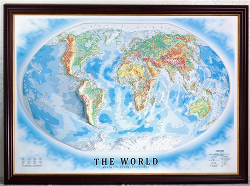
High Raised Relief Panorama Map of the World 44" x 32"
Product Code: 6961
Our Price: $295.00
Description
There are maps, and there are raised relief maps. Now avaialble are these High raised relief maps that give you a true sense of a locations height! Now you can see how the Swiss Alps compare to the Andes mountains.
High-raised relief panoramas are a
class of relief maps with increased landscape volume. Relief height from
1" to 3†above the surface.
Creates the effect of increased land volume from a bird's-eye view with the real dynamics and detailed characteristics of mountain relief.
Functional, Illustrative Cartographic Art
TESTPLAY's High Raised Relief Panoramas are recommended for use in schools, colleges, universities, engineering, offices, homes, libraries, and decor.
Maps are 44 x 32 inches with a 35x vertical exaggeration. made of PVC plastic.Due to the size of this product shipping will cost a flat rate of $85 within the Continental US. International, HI, AK & PR orders should contact us for a price quote.
NOTE: Images may show framed map, or with foam core backing. These options are listed in the pull-down menu.
Buying in quantity? Please contact us below or by phone for improved pricing and shipping options.
Email a question about this item